

Wow Woodbridge- Main Street
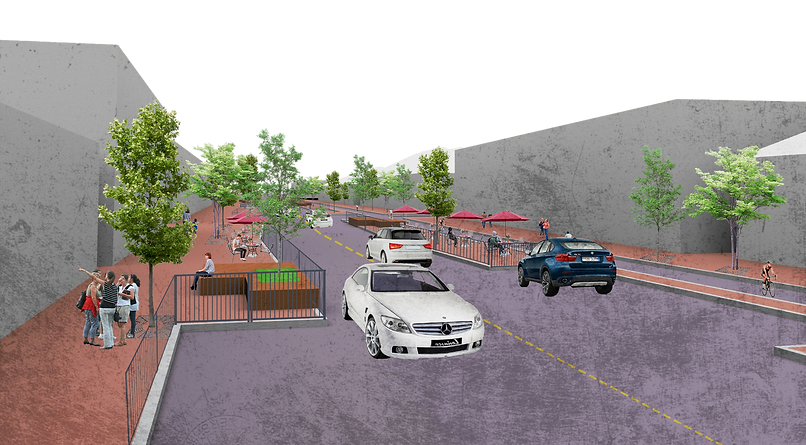
Woodbridge posed a great opportunity to create an overall connection throughout the township. A bike lane was carefully implemented along the major corridors surrounding neighborhoods to highlight prominent landmarks within Woodbridge. Green Street, Main Street, School Street, Metuchen Ave and Rahway Ave can be seen with new traffic patterns and street dimensions to make a bike lane possible. The bike lane works to create a connection to the Woodbridge Mall, Heards Brook, and Main Street which was redesigned to make it more of a destination and caters more to leisure activities to enjoy the local businesses. Main Street was designed to feature seating plazas with wooden benches, outdoor dining, and more street trees to make the area more pedestrian friendly which differs greatly from the more vehicle focussed Main Street seen today. This was accomplished by reimagining side walk width and including islands which help create seating areas, bump-ins for parking and bus stops, and help decrease cross walk distance making Main Street more pedestrian friendly.
inventory map

Woodbridge currently exists as a compiling of important landmarks. These include the mall, Heards Brook, Main Street, and the now delineated Blue Acres area. Given these juxtaposed elements and their accessibility via major traffic corridors such as route 9, the turnpike, and the train station, the ultimate goal was to connect these elements while making each space less transportation heavy and focus more on pedestrian access.
demographics


These maps show demographic based on census tract. Woodbridge is known for their diversity and these maps showed potential links to culture and design and who we are designing for.
analysis

This map begins to compile ideas for the overall scope of Woodbridge based on a process called morphological box. This process takes status quos based on the existing conditions of a space or site and helps create new options of how the space can be redesigned while considering those design criteria. The best options for each status quo is then synthesized into one map becoming an analysis map that then assists in creating a concept. This morphological box can be accessed here.
concept

This section of the project focuses on Main Street. The idea for Main Street was to be designed around the location of current business and how to design for them. The idea was to incorporate spaces for outdoor dining alternated with spaces for vehicular traffic. Orange dots resemble restaurants and the blue dots resemble other types of businesses. This allowed to know which areas could be dedicated for pedestrians or cars. The red line resembles a rough estimate on the bump outs to extend the sidewalk to activate Main Street.

This group of drawings look more into traffic patters and imagining how the space would look once those spaces are activated with those seating areas and including a potential bike lane integrated with the sidewalk.


These diagrams show how Main Street begins to change after considering dimensionality. The orange shows the changes to the sidewalk showcasing either a sidewalk extension or an island. The idea was to increase more sidewalk space and slow traffic to ensure pedestrian safety.

main street Site Plan

Main street Sections


Main street Perspective
Traffic diagrams

Green St & Amboy Ave

Green St & School St

Main St & Rahway Ave

Main St & Amboy Ave

Green St & Rahway Ave
The next two set of diagrams are showing the imagination of the streets after incorporating the bike lane system. Because of the bike lane system, the streets had to be redesigned to retain proper dimensions for traffic regulations ensuring the safety of vehicular travel, bicycle travel, and pedestrian travel. This was done through shortening the width vehicular lanes in some cases, including buffers for bike lanes, and creating islands for pedestrian crosswalks for wider roads all while attempting to retain existing elements such as the amount of existing lanes and on-street parking and as best as possible.
traffic sections
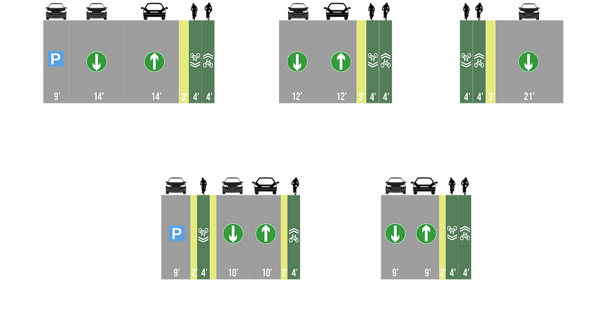
Rahway Ave
Metuchen Ave
School St
Main St
Green St